Our Unstable Shores
By ELLIOTT ROBERTS
Nature Magazine, September 1937
The seas do not like their living quarters. So they build up, tear down, and rearrange their beds. All of which adds to the labor of man, self-appointed recorder of the changing movements of the sea and their effect on the contour of the land.
The earliest explorers of our shores knew nothing of the deeps and shoals; they were blind men groping in a strange house. The situation is now remedied by charts of our oceans and coastal waters, so that great ships steam confidently where the first comers had to sound their cautious way. Still, we are forever confronted with the sea's restless changes deepening here, shoaling there and the advance or recession of the shoreline on many a mile of coast. The chartmakers must be forever alert to the latest changes, to keep the charts accurate.
A surveyor, busy on the coast of South Carolina, stood by his instrument on the sandy beach, just out of reach of the breaking waves. He calculated the location of the station where he stood, and was about to put it down on the chart, when he blinked. What• had he found? He checked his work, and it was correct. According to the old chart his station lay in water many feet deep, half a mile from the nearest dry land! High time he was there, checking old man ocean's latest vagary!
The United States Coast and Geodetic Survey, chartmakers for the United States, maintains eternal vigilance to keep abreast of all the changes that occur, especially on the more unstable and shifting portions of our coast. In many of these thousands of miles of shoreline, even a few years will see enormous changes. The point of Rockaway Beach, opposite New York Harbor, grows westward some 250 feet yearly, a matter of several miles in a lifetime. Long Beach, Coney Island and Sandy Hook are all extending themselves toward the channel.
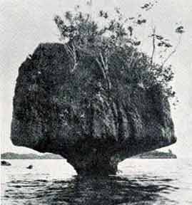
NO MATCH FOR THE POWER OF THE WAVES
Not long ago a party of the Coast and Geodetic Survey surveyed a new channel leading to a Florida port. It was newly-dredged, and they found almost exactly the depths specified in the construction contracts. There were certain conditions, obvious to the experts of the survey party, that indicated the possibility of future changes in the depth of the channel. A few months later, as a matter of verification, they revisited the place, and found the channel six feet or more shallower than on their first sounding. Immediately the port authorities ordered further dredging operations. The chartmaker, in the face of changes such as these, must be ever active if his charts are to merit the navigator's confidence.
Mariners, unable to see the sea-bed beneath their ships, must guide themselves largely by bearings on natural or artificial landmarks ashore. There, on dry land, one might assume that the natural landmarks do not change. The chartmakers have found, however, that nothing can be taken for granted. In a navigable inland bay in Florida they recently discovered a group of wooded islands, "grown" out of the water close by a well-traveled route for vessels. They had appeared in a place shown by previous surveys to be clear, unbroken water. Did not the surveyors keep abreast of such changes, the navigator, searching the charts to identify the surrounding visible land, soon would be confused and helpless.
These changes are not all concerned with remote and unimportant places. Fishing Point, on the Virginia coast, grew southward some three miles within fifty years, converting an area of exposed water into a sheltered place. It eventually formed a natural harbor of refuge, and now is sought by fishing craft in times of storm.
That was a happy occurrence, and the chartmakers kept track of the changes, repeatedly producing new charts of the area. A strange thing about this natural phenomenon is that the point has by now grown so near the opposite beach as to threaten a complete juncture, closing the little harbor that has been so valuable to fishermen. It is probable that in the course of centuries this cycle will be repeated many times.
Similar changes are taking place, in unseen ways, along the sands of the ocean bottom miles from land. Shoals and bars will wash away under certain conditions of wave and current, only to build up again when the elements change their line of attack. Many shoals are under-water sand dunes, rolling along under the persistent attack of the water. The particles of sand are washed up on the seaward side till they fall over the crest and go tumbling down again. This results in a slow but definite displacement of the whole shoal. Resurveys will sometimes show whole groups of shoals, like desert dunes, traveling apace in one direction.
Recent advances in the art of marine surveying have done much to make the work more rapid and efficient. We can now keep really up-to-date in our knowledge of the seas. Thanks to the fathometer, one of the most remarkable of the instruments of modern navigation, continuous depth readings are made while the ship steams along her course. A tremendous amount of comprehensive reconnaissance can be performed without undue expenditure of time. The survey ships turn out their charts in far shorter time than formerly, when all soundings were "leadline casts" from ships whose speed had to be reduced to nearly zero. For the correct placing of the soundings on the chart the surveyor no longer has to see his signal beacons along the shore. He measures hundreds of miles by timing the passage of sound signals through the water, carrying his positions with accuracy into remote regions, even in fog or the darkness of night. The surveyor no longer plods laboriously through the coastal swamps and thickets to make his measurements. He has the system called "air phototopography", basing his charts and maps on photographs taken vertically from airplanes in flight The precision demanded by the charts is attained by an accurate, though rapid ground survey to fix the exact locations of certain objects visible in the photographs. A few hours of flight will afford thousands of pictures, each containing a wealth of land detail that could formerly have been plotted only after years of labor.
We seek, not only to portray, but to control and direct the forces of the sea. Fortunes have been spent, many of them fruitlessly, in efforts to safeguard waterfront property. In time, however, perfection in this direction will certainly be approached. Just as medicine, chemistry and the other scientific arts have approached more nearly to the ultimate goal, domination over the forces of Nature, so will this science, dealing with what are perhaps the greatest forces in the world, approach perfection.
 Printer-friendly version